Ragiv:ক্যাম্ব্রিয়ান৫০.png
Size of this preview: 800 × 444 pixels. Other resolutions: 320 × 178 pixels • 640 × 355 pixels • 1,106 × 614 pixels.
Ragiv rigik (1,106 × 614 pixel, ragivagret: 311 KB, pated MIME: image/png)
Plän brefik
| Bepenam |
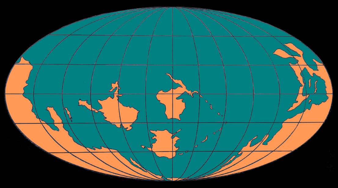
English: The approximate map of earth 500 million years ago, in the late Cambrian period. বাংলা: আনুমানিক ৫০ কোটি বছর আগে ভূতাত্ত্বিক ক্যাম্ব্রিয়ান যুগে পৃথিবীর সম্ভাব্য মানচিত্র। নীল অংশ জলভাগ ও কমলা অংশ স্থল। |
| Dät | |
| Fon | Vobot okik |
| Lautan | ব্যা করণ |
Dälastad
I, the copyright holder of this work, hereby publish it under the following license:
| This file is made available under the Creative Commons CC0 1.0 Universal Public Domain Dedication. | |
| The person who associated a work with this deed has dedicated the work to the public domain by waiving all of their rights to the work worldwide under copyright law, including all related and neighboring rights, to the extent allowed by law. You can copy, modify, distribute and perform the work, even for commercial purposes, all without asking permission.
|
Jenotem ragiva
Välolös däti/timi ad logön ragivi soäsä äbinon ün tim at.
| Dät/Tim | Magodil | Mafots | Geban | Küpet | |
|---|---|---|---|---|---|
| anuik | 04:36, 2015 mayul 14id | | 1,106 × 614 (311 KB) | ব্যা করণ | User created page with UploadWizard |
Yüms
Pads sököl payümons ko pad at:
Ragivigeb Valöpik
The following other wikis use this file:
- Geb su af.wikipedia.org
- Geb su bn.wikipedia.org
- Geb su de.wikipedia.org
- Geb su en.wikipedia.org
- Phanerozoic
- La Quinta Formation
- Paja Formation
- Marichuela Formation
- Chipaque Formation
- Guadalupe Group
- Subachoque Formation
- Guaduas Formation
- Bogotá Formation
- Usme Formation
- Regadera Formation
- Floresta Formation
- Sabana Formation
- Soatá Formation
- Arcabuco Formation
- Honda Group, Colombia
- Cuche Formation
- Las Juntas Formation
- Macanal Formation
- Río Cachirí Group
- Barzalosa Formation
- Fómeque Formation
- Une Formation
- Rosablanca Formation
- Loma Gorda Formation
- Caballos Formation
- Venado Formation
- Template:Stratigraphy of the Llanos Basin
- Llanos Basin
- Santa Teresa Formation, Colombia
- Noreán Formation
- Geb su en.wikiversity.org
- Geb su fi.wikibooks.org
- Geb su kw.wikipedia.org
- Geb su ms.wikipedia.org
- Geb su ne.wikipedia.org
- Geb su pt.wikipedia.org
- Geb su si.wikipedia.org
- Geb su zh.wikipedia.org