Ragiv:Plattsburgh city border map.gif
Gretot gudikum no pagebidon.
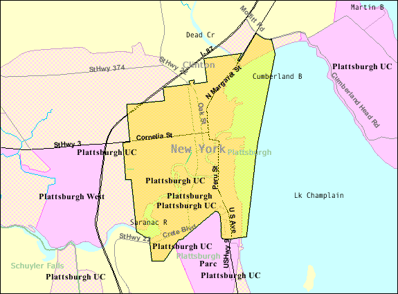
Plattsburgh_city_border_map.gif (575 × 425 pixel, ragivagret: 32 KB, pated MIME: image/gif)
Plän brefik
| Bepenam |
English: Map of Plattsburgh from U.S. Census website. |
| Fon | |
| Lautan |
Dälastad
This image or file is a work of a United States Census Bureau employee, taken or made as part of that person's official duties. As a work of the U.S. federal government, the image is in the public domain.
|
 |
Original upload log
The original description page was here. All following user names refer to en.wikipedia.
- 2007-11-26 19:24 Fife Club 575×425× (32778 bytes) Map of [[Plattsburgh (city), New York]] from U.S. Census website.
Jenotem ragiva
Välolös däti/timi ad logön ragivi soäsä äbinon ün tim at.
| Dät/Tim | Magodil | Mafots | Geban | Küpet | |
|---|---|---|---|---|---|
| anuik | 02:19, 2013 gustul 23id | | 575 × 425 (32 KB) | Dcirovic | {{Information |Description={{en|Map of en:Plattsburgh (city), New York from U.S. Census website.}} |Source=Transferred from [http://en.wikipedia.org en.wikipedia] |Date={{Original upload date|2007-11-26}} |Author=Original uploader was {{user at p... |
Yüms
Pads sököl payümons ko pad at:
Ragivigeb Valöpik
The following other wikis use this file:
- Geb su ar.wikipedia.org
- Geb su arz.wikipedia.org
- Geb su azb.wikipedia.org
- Geb su ca.wikipedia.org
- Geb su ceb.wikipedia.org
- Geb su cy.wikipedia.org
- Geb su el.wikipedia.org
- Geb su en.wikipedia.org
- Geb su eo.wikipedia.org
- Geb su eu.wikipedia.org
- Geb su fr.wikipedia.org
- Geb su ht.wikipedia.org
- Geb su hu.wikipedia.org
- Geb su ja.wikipedia.org
- Geb su sr.wikipedia.org
- Geb su sv.wikipedia.org
- Geb su tt.wikipedia.org
- Geb su www.wikidata.org
- Geb su zh-min-nan.wikipedia.org