Ragiv:Map of Kentucky highlighting Montgomery County.svg

Size of this PNG preview of this SVG file: 800 × 345 pixels. Other resolutions: 320 × 138 pixels • 640 × 276 pixels • 1,024 × 441 pixels • 1,280 × 551 pixels • 2,560 × 1,103 pixels • 6,770 × 2,916 pixels.
Ragiv rigik (ragiv in fomät: SVG, magodaziöbs 6,770 × 2,916, gretot: 127 KB)
Plän brefik
| Bepenam |
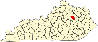
English: This is a locator map showing Montgomery County in Kentucky. For more information, see Commons:United States county locator maps. |
| Dät | |
| Fon |
Vobot okik: English: The maps use data from nationalatlas.gov, specifically countyp020.tar.gz on the Raw Data Download page. The maps also use state outline data from statesp020.tar.gz. The Florida maps use hydrogm020.tar.gz to display Lake Okeechobee. |
| Lautan | David Benbennick |
Dälastad
| I, the copyright holder of this work, release this work into the public domain. This applies worldwide. In some countries this may not be legally possible; if so: I grant anyone the right to use this work for any purpose, without any conditions, unless such conditions are required by law. |
Jenotem ragiva
Välolös däti/timi ad logön ragivi soäsä äbinon ün tim at.
| Dät/Tim | Magodil | Mafots | Geban | Küpet | |
|---|---|---|---|---|---|
| anuik | 12:23, 2006 febul 12id | | 6,770 × 2,916 (127 KB) | David Benbennick | {{subst:User:Dbenbenn/clm|county=Montgomery County|state=Kentucky}} |
Yüms
Pads sököl payümons ko pad at:
Ragivigeb Valöpik
The following other wikis use this file:
- Geb su ar.wikipedia.org
- Geb su arz.wikipedia.org
- Geb su bg.wikipedia.org
- Geb su bpy.wikipedia.org
- Geb su ca.wikipedia.org
- Geb su cdo.wikipedia.org
- Geb su ceb.wikipedia.org
- Geb su ce.wikipedia.org
- Geb su cs.wikipedia.org
- Geb su cy.wikipedia.org
- Geb su de.wikipedia.org
- Geb su en.wikipedia.org
- Montgomery County, Kentucky
- Camargo, Kentucky
- Jeffersonville, Kentucky
- Mount Sterling, Kentucky
- List of counties in Kentucky
- Judy, Kentucky
- Template:Montgomery County, Kentucky
- User:Nyttend/County templates/KY/2
- National Register of Historic Places listings in Montgomery County, Kentucky
- Category:Populated places in Montgomery County, Kentucky
- Lucky Stop, Kentucky
- Hope, Kentucky
- Plum Lick, Kentucky
- Stepstone, Kentucky
- Bogy-Chenault, Kentucky
- Calk, Kentucky
- Stoops, Kentucky
- Template:MontgomeryCountyKY-geo-stub
- Geb su eo.wikipedia.org
- Geb su es.wikipedia.org
- Geb su et.wikipedia.org
- Geb su eu.wikipedia.org
- Geb su fa.wikipedia.org
- Geb su fa.wikivoyage.org
- Geb su frr.wikipedia.org
- Geb su fr.wikipedia.org
View more global usage of this file.