Ragiv:Ladispoli Aerial.jpg

Size of this preview: 800 × 438 pixels. Other resolutions: 320 × 175 pixels • 640 × 351 pixels • 1,024 × 561 pixels • 1,580 × 866 pixels.
Ragiv rigik (1,580 × 866 pixel, ragivagret: 1,018 KB, pated MIME: image/jpeg)
Plän brefik
| Bepenam |
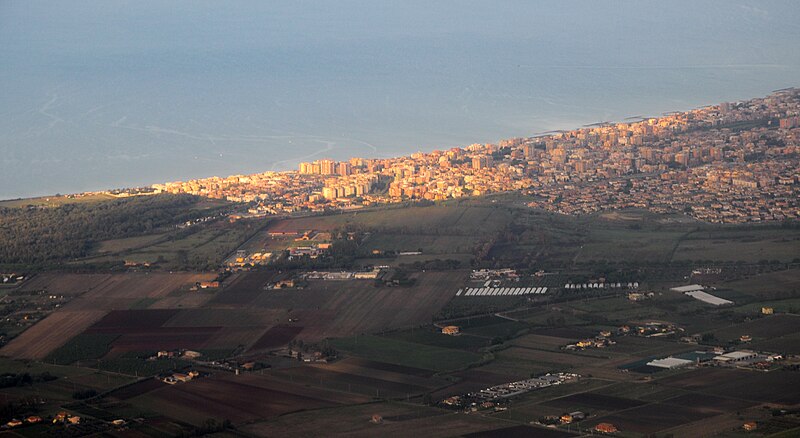
English: Aerial view of the town of Ladispoli, located about 25 km northwest of Rome. The Tyrrhenian Sea is seen in the background. |
| Dät | |
| Fon | Vobot okik |
| Lautan | MrPanyGoff |
| Camera location | | View this and other nearby images on: OpenStreetMap |
|---|
Dälastad
I, the copyright holder of this work, hereby publish it under the following license:
This file is licensed under the Creative Commons Attribution-Share Alike 4.0 International license.
- Binol libik:
- to share – to copy, distribute and transmit the work
- to remix – to adapt the work
- Under the following conditions:
- attribution – You must give appropriate credit, provide a link to the license, and indicate if changes were made. You may do so in any reasonable manner, but not in any way that suggests the licensor endorses you or your use.
- share alike – If you remix, transform, or build upon the material, you must distribute your contributions under the same or compatible license as the original.
Jenotem ragiva
Välolös däti/timi ad logön ragivi soäsä äbinon ün tim at.
| Dät/Tim | Magodil | Mafots | Geban | Küpet | |
|---|---|---|---|---|---|
| anuik | 11:26, 2016 tobul 5id | | 1,580 × 866 (1,018 KB) | MrPanyGoff | User created page with UploadWizard |
Yüms
Pads sököl payümons ko pad at:
Ragivigeb Valöpik
The following other wikis use this file:
- Geb su br.wikipedia.org
- Geb su ca.wikipedia.org
- Geb su ceb.wikipedia.org
- Geb su ce.wikipedia.org
- Geb su da.wikipedia.org
- Geb su eo.wikipedia.org
- Geb su es.wikipedia.org
- Geb su eu.wikipedia.org
- Geb su fr.wikipedia.org
- Geb su hu.wikipedia.org
- Geb su ia.wikipedia.org
- Geb su it.wikipedia.org
- Geb su lij.wikipedia.org
- Geb su lld.wikipedia.org
- Geb su lmo.wikipedia.org
- Geb su nn.wikipedia.org
- Geb su pl.wikipedia.org
- Geb su ro.wikipedia.org
- Geb su ru.wikipedia.org
- Geb su sr.wikipedia.org
- Geb su sv.wikipedia.org
- Geb su sw.wikipedia.org
- Geb su tt.wikipedia.org
- Geb su uk.wikipedia.org
- Geb su uz.wikipedia.org
- Geb su vec.wikipedia.org
- Geb su www.wikidata.org
- Geb su zh.wikipedia.org