Ragiv:Quai Maréchal de Lattre de Tassigny, Sète 02.jpg
Size of this preview: 800 × 500 pixels. Other resolutions: 320 × 200 pixels • 640 × 400 pixels • 1,024 × 640 pixels • 1,280 × 800 pixels • 2,560 × 1,600 pixels • 5,955 × 3,722 pixels.
Ragiv rigik (5,955 × 3,722 pixel, ragivagret: 14.63 MB, pated MIME: image/jpeg)
| Bepenam | |
| Dät | |
| Fon | Vobot okik |
| Lautan | Christian Ferrer |
| Däl (Reusing this file) |
I, the copyright holder of this work, hereby publish it under the following license: This file is licensed under the Creative Commons Attribution-Share Alike 3.0 Unported license.
|
| Camera location | | View this and other nearby images on: OpenStreetMap |
|---|
|
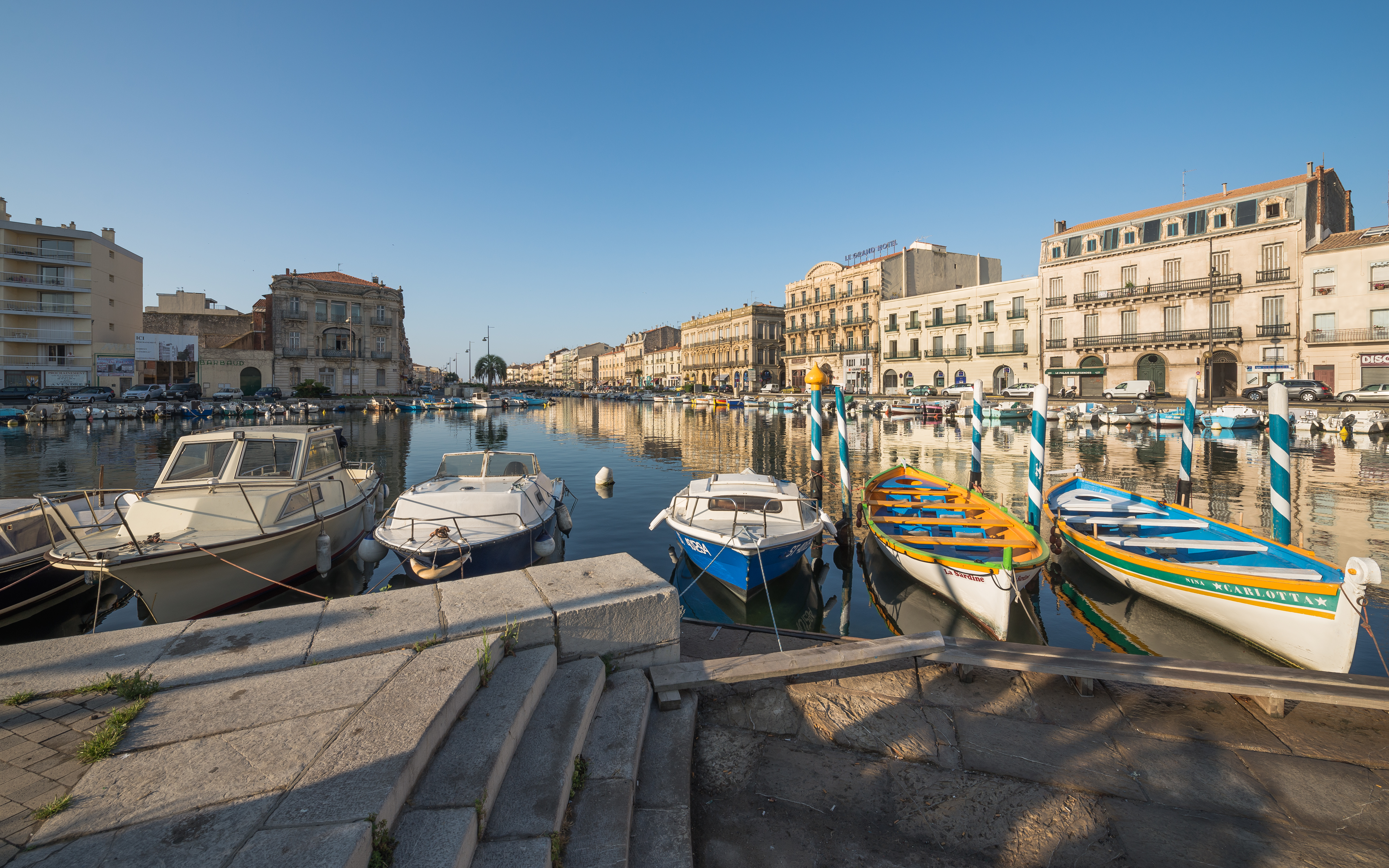
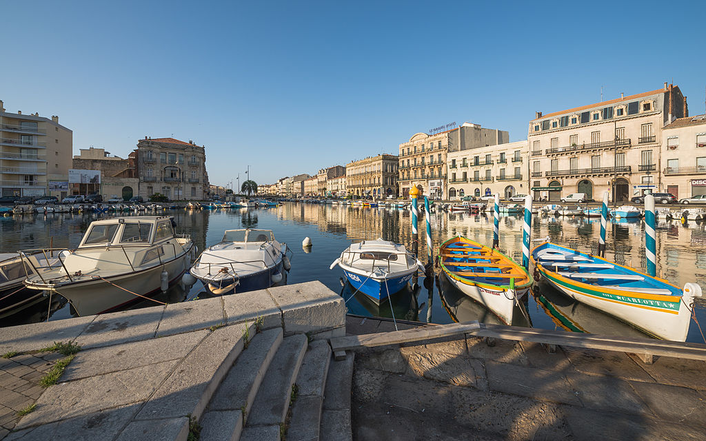
This image was selected as picture of the day on Wikimedia Commons for 5 March 2014. It was captioned as follows: English: The Maréchal de Lattre de Tassigny Embankment and the Canal of La Peyrade. Sète, Hérault, France. Other languages:
Bosanski: Maréchal de Lattre de Tassigny Embankment i kanal La Peyrade. Sète, Hérault, Francuska. English: The Maréchal de Lattre de Tassigny Embankment and the Canal of La Peyrade. Sète, Hérault, France. Français : Le Quai Maréchal de Lattre de Tassigny et le Canal de La Peyrade à Sète, dans l'Hérault en France. Magyar: A Maréchal de Lattre de Tassigny rakpart és a La Peyrade csatorna, Sète (Franciaország, Hérault megye) Nederlands: De kade Maréchal de Lattre de Tassigny en het kanaal van La Peyrade in Sète in het departement Hérault in Frankrijk. Русский: Вид на набережную маршала де Латтра де Тассиньи и канал Ла-Пейрад с набережной Луи Пастера в Сете (Франция). 中文: 法国塞特港拉佩拉德运河。 |
Jenotem ragiva
Välolös däti/timi ad logön ragivi soäsä äbinon ün tim at.
| Dät/Tim | Magodil | Mafots | Geban | Küpet | |
|---|---|---|---|---|---|
| anuik | 10:19, 2013 setul 1id | | 5,955 × 3,722 (14.63 MB) | Christian Ferrer | less clarity and contrast |
| 09:38, 2013 setul 1id |  | 5,955 × 3,722 (15.18 MB) | Christian Ferrer | reworked | |
| 04:36, 2013 gustul 13id |  | 4,695 × 2,934 (8.2 MB) | Christian Ferrer | Reverted to version as of 05:04, 31 July 2013 | |
| 17:11, 2013 gustul 6id |  | 4,695 × 2,934 (8.09 MB) | Christian Ferrer | more dark | |
| 05:04, 2013 yulul 31id |  | 4,695 × 2,934 (8.2 MB) | Christian Ferrer | User created page with UploadWizard |
Yüms
Pads sököl payümons ko pad at:
Ragivigeb Valöpik
The following other wikis use this file:
- Geb su be-tarask.wikipedia.org
- Geb su bg.wikipedia.org
- Geb su bn.wikipedia.org
- Geb su ca.wikipedia.org
- Geb su crh.wikipedia.org
- Geb su cv.wikipedia.org
- Geb su de.wikipedia.org
- Geb su en.wikipedia.org
- Geb su eo.wikipedia.org
- Geb su fa.wikipedia.org
- Geb su fr.wikipedia.org
- Geb su fr.wikivoyage.org
- Geb su gl.wikipedia.org
- Geb su hu.wikipedia.org
- Geb su id.wikipedia.org
- Geb su is.wiktionary.org
- Geb su it.wikipedia.org
- Geb su ka.wikipedia.org
- Geb su ko.wikipedia.org
- Geb su krc.wikipedia.org
- Geb su lbe.wikipedia.org
- Geb su oc.wikipedia.org
- Geb su os.wikipedia.org
- Geb su pt.wikipedia.org
- Geb su ru.wikipedia.org
- Geb su ru.wikinews.org
- Geb su sah.wikipedia.org
- Geb su sh.wikipedia.org
- Geb su sr.wikipedia.org
- Geb su sv.wikipedia.org
- Geb su ta.wikipedia.org
- Geb su tt.wikipedia.org
- Geb su uk.wikipedia.org
- Geb su vi.wikipedia.org
- Geb su war.wikipedia.org
- Geb su xal.wikipedia.org
- Geb su zh.wikipedia.org