Ragiv:Blois Loire Panorama - July 2011.jpg

Size of this preview: 800 × 274 pixels. Other resolutions: 320 × 109 pixels • 640 × 219 pixels • 1,024 × 350 pixels • 1,280 × 438 pixels • 2,560 × 876 pixels • 12,000 × 4,105 pixels.
Ragiv rigik (12,000 × 4,105 pixel, ragivagret: 14.95 MB, pated MIME: image/jpeg)
|
Plän brefik
| Bepenam |
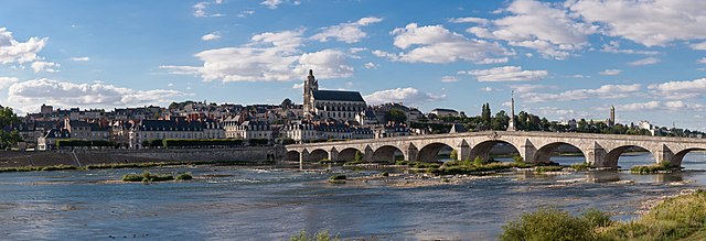
English: A 28 segment (2 x 14) panoramic view of Blois as viewed from the south-east on the far side of the Loire River.
Français : Vue panoramique de Blois (Loir-et-Cher, France), avec notamment le pont Jacques-Gabriel sur la Loire, la cathédrale Saint-Louis, et tout à droite le clocher de la basilique Notre-Dame de la Trinité |
| Dät | |
| Fon | Vobot okik |
| Lautan | Diliff |
| Däl (Reusing this file) |
Summary:In using this image or any subsequent derivatives of it, you are required to release the image under the same license. As such, any reproduction of this image, in any medium, must appear with a copy of, or full URL of the license.Attribution of this image to the author (DAVID ILIFF) is also required, preferably in a prominent location near the image.No other conditions may be added to, or removed from this license without the permission of the author and copyright holder.Suggested attribution: "Photo by DAVID ILIFF. License: CC BY-SA 3.0"Please review the full license requirements carefully before using this image. If you would like to clarify the terms of the license or negotiate less restrictive commercial licensing outside of the bounds of GFDL/CC-BY-SA, please contact me by email, or if you don't have a Wikipedia account you can either leave a message on my talk page with your contact details and your request, or you can contact me on Facebook. Please also send a 'friend request' to ensure that I am aware of your message. |
| Camera location | | View this and other nearby images on: OpenStreetMap |
|---|

|
NOTE: This image is a panorama consisting of multiple frames that were merged or stitched in software. As a result, this image necessarily underwent some form of digital manipulation. These manipulations may include blending, blurring, cloning, and colour and perspective adjustments. As a result of these adjustments, the image content may be slightly different from reality at the points where multiple images were combined. This manipulation is often required due to lens, perspective, and parallax distortions.
|
This image has been assessed using the Quality image guidelines and is considered a Quality image.
|
Dälastad
I, the copyright holder of this work, hereby publish it under the following licenses:
This file is licensed under the Creative Commons Attribution-Share Alike 3.0 Unported license.
- Binol libik:
- to share – to copy, distribute and transmit the work
- to remix – to adapt the work
- Under the following conditions:
- attribution – You must give appropriate credit, provide a link to the license, and indicate if changes were made. You may do so in any reasonable manner, but not in any way that suggests the licensor endorses you or your use.
- share alike – If you remix, transform, or build upon the material, you must distribute your contributions under the same or compatible license as the original.

|
Däl pagevon ad kopiedön, seagivön e/u votükön dokümi at ma Dälazöt ad Dokümam Libik: GNU, Fomam: 1.2 u nulikum fa el Free Software Foundation (Stitod: Nünömaprograms libik); nen diläds nevotükovik, nen vödems tegapada balid, e leigo nen vödems tegapada lätik. Kopied dälazöta pekeninon in diläd: Dälazöt ad Dokümam Libik: GNU panemöl. |
You may select the license of your choice.
Jenotem ragiva
Välolös däti/timi ad logön ragivi soäsä äbinon ün tim at.
| Dät/Tim | Magodil | Mafots | Geban | Küpet | |
|---|---|---|---|---|---|
| anuik | 20:31, 2011 gustul 14id | 12,000 × 4,105 (14.95 MB) | Gzzz | Deletion of cloned men on the bridge (Modification asked by Tomer T) | |
| 11:07, 2011 gustul 4id | 12,000 × 4,105 (14.94 MB) | Diliff | {{Information |Description ={{en|1=A 28 segment (2 x 14) panoramic view of Blois as viewed from the south-east on the far side of the Loire River.}} |Source ={{own}} |Author =Diliff |Date =2011-07-10 |Permissio |
Yüms
Pads sököl payümons ko pad at:
Ragivigeb Valöpik
The following other wikis use this file:
- Geb su an.wikipedia.org
- Geb su ar.wikipedia.org
- Geb su arz.wikipedia.org
- Geb su azb.wikipedia.org
- Geb su bm.wikipedia.org
- Geb su br.wikipedia.org
- Geb su cs.wikipedia.org
- Geb su de.wikivoyage.org
- Geb su el.wikipedia.org
- Geb su en.wikipedia.org
- Blois
- Portal:Geography
- Portal:Geography/Featured picture
- User:Diliff
- Wikipedia:Featured pictures/Places/Panorama
- User:Tomer T
- User talk:Tomer T/Archive 1
- Talk:Blois
- Wikipedia:Featured pictures thumbs/28
- Wikipedia:Featured picture candidates/August-2011
- Wikipedia:Featured picture candidates/Blois panorama
- Wikipedia:Wikipedia Signpost/2011-08-29/Featured content
- User talk:Diliff/Archive9
- Wikipedia:Picture of the day/January 2013
- Template:POTD/2013-01-14
- Wikipedia:Main Page history/2013 January 14
- Portal:Geography/Featured picture/23
- User talk:Diliff/Archive10
- Wikipedia:Wikipedia Signpost/Single/2011-08-29
- Jacques-Gabriel Bridge
- Geb su eo.wikipedia.org
- Geb su es.wikipedia.org
- Geb su fa.wikipedia.org
- Geb su fi.wikipedia.org
- Geb su fr.wikipedia.org
- Geb su fr.wikivoyage.org
View more global usage of this file.