Ragiv:Beringen Limburg Belgium Map.png
Gretot gudikum no pagebidon.
Beringen_Limburg_Belgium_Map.png (270 × 203 pixel, ragivagret: 5 KB, pated MIME: image/png)

|
This locator map image could be re-created using vector graphics as an SVG file. This has several advantages; see Commons:Media for cleanup for more information. If an SVG form of this image is available, please upload it and afterwards replace this template with
{{vector version available|new image name}}.
It is recommended to name the SVG file “Beringen Limburg Belgium Map.svg”—then the template Vector version available (or Vva) does not need the new image name parameter. |
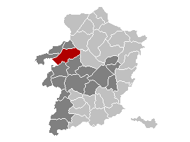
Map, municipality belgium Beringen
| This work has been released into the public domain by its author, LennartBolks. This applies worldwide. In some countries this may not be legally possible; if so: |
FR; Carte indiquant la localisation de la commune de Beringen dans la Province de Limbourg.
EN; Map from w:nl:Gebruiker:LennartBolks/kaartenhoekje in Public Domain by the Author choice.
Jenotem ragiva
Välolös däti/timi ad logön ragivi soäsä äbinon ün tim at.
| Dät/Tim | Magodil | Mafots | Geban | Küpet | |
|---|---|---|---|---|---|
| anuik | 00:25, 2006 prilul 12id | | 270 × 203 (5 KB) | Profoss | |
| 10:35, 2005 prilul 9id |  | 270 × 203 (4 KB) | Nicnac25~commonswiki | Map, municipality belgium Beringen {{PD}} FR; Carte indiquant la localisation de la commune de Beringen dans la Province de Limbourg. EN; Map from w:nl:Gebruiker:LennartBolks/kaartenhoekje in Public Domain by the Author choice. [[Category:Maps of pro |
Yüms
Pads nonik peyümons ad ragiv at.
Ragivigeb Valöpik
The following other wikis use this file:
- Geb su af.wikipedia.org
- Geb su eo.wikipedia.org
- Geb su fa.wikipedia.org
- Geb su it.wikipedia.org
- Geb su li.wikipedia.org
- Geb su pt.wikipedia.org
- Geb su ro.wikipedia.org
- Geb su sk.wikipedia.org
- Geb su sv.wikipedia.org
- Geb su th.wikipedia.org
- Geb su tr.wikipedia.org
- Geb su vi.wikipedia.org