Ragiv:AnderlechtLocatie.png
Gretot gudikum no pagebidon.
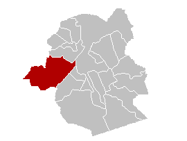
AnderlechtLocatie.png (270 × 203 pixel, ragivagret: 3 KB, pated MIME: image/png)

|
File:Anderlecht Brussels-Capital Belgium Map.svg is a vector version of this file. It should be used in place of this PNG file when not inferior.
File:AnderlechtLocatie.png → File:Anderlecht Brussels-Capital Belgium Map.svg
For more information, see Help:SVG. |
 |
Plän brefik
| Bepenam |
English: Map of municipality Anderlecht, Belgium Nederlands: Gemeentekaart Anderlecht |
| Dät | |
| Fon | Vobot okik |
| Lautan | Gebruiker:LennartBolks |
Dälastad
| This work has been released into the public domain by its author, LennartBolks. This applies worldwide. In some countries this may not be legally possible; if so: |
Jenotem ragiva
Välolös däti/timi ad logön ragivi soäsä äbinon ün tim at.
| Dät/Tim | Magodil | Mafots | Geban | Küpet | |
|---|---|---|---|---|---|
| anuik | 21:46, 2005 setul 26id | | 270 × 203 (3 KB) | Cicero | From wikipedia-nl: nl:AnderlechtLocatie.png *first upload 10 jan 2004 20:54 by nl:Gebruiker:LennartBolks *description: Gemeentekaart, eigen werk *created by nl:Gebruiker:LennartBolks {{PD}} Category:Maps of Belgium |
Yüms
Pads nonik peyümons ad ragiv at.
Ragivigeb Valöpik
The following other wikis use this file:
- Geb su pt.wikipedia.org