Ragiv:Sweden Kalmar location map.svg

Size of this PNG preview of this SVG file: 327 × 599 pixels. Other resolutions: 131 × 240 pixels • 262 × 480 pixels • 419 × 768 pixels • 559 × 1,024 pixels • 1,118 × 2,048 pixels • 546 × 1,000 pixels.
Ragiv rigik (ragiv in fomät: SVG, magodaziöbs 546 × 1,000, gretot: 217 KB)
Plän brefik
| Bepenam |
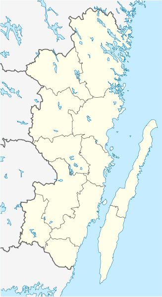
English: Location map of Kalmar County in Sweden. N-S stretching is 183%, geographic limits of the map:
Deutsch: Positionskarte von Kalmar län in Schweden. N-S-Streckung beträgt 183%, geographische Begrenzung der Karte:
|
| Dät | |
| Fon | Vobot okik |
| Lautan | Erik Frohne |
| Other versions | Derivative works of this file: Öland Municipal centres.svg |
Dälastad
I, the copyright holder of this work, hereby publish it under the following licenses:

|
Däl pagevon ad kopiedön, seagivön e/u votükön dokümi at ma Dälazöt ad Dokümam Libik: GNU, Fomam: 1.2 u nulikum fa el Free Software Foundation (Stitod: Nünömaprograms libik); nen diläds nevotükovik, nen vödems tegapada balid, e leigo nen vödems tegapada lätik. Kopied dälazöta pekeninon in diläd: Dälazöt ad Dokümam Libik: GNU panemöl. |
This file is licensed under the Creative Commons Attribution 3.0 Unported license.
- Binol libik:
- to share – to copy, distribute and transmit the work
- to remix – to adapt the work
- Under the following conditions:
- attribution – You must give appropriate credit, provide a link to the license, and indicate if changes were made. You may do so in any reasonable manner, but not in any way that suggests the licensor endorses you or your use.
You may select the license of your choice.
Jenotem ragiva
Välolös däti/timi ad logön ragivi soäsä äbinon ün tim at.
| Dät/Tim | Magodil | Mafots | Geban | Küpet | |
|---|---|---|---|---|---|
| anuik | 08:23, 2009 yanul 27id | | 546 × 1,000 (217 KB) | Erik Frohne | Waterline adjusted |
| 16:26, 2009 yanul 18id |  | 546 × 1,000 (216 KB) | Erik Frohne | Added some lakes Category:Location maps of Sweden | |
| 09:58, 2009 yanul 17id |  | 546 × 1,000 (183 KB) | Erik Frohne | {{Information |Description={{en|1=Location map of Kalmar in Sweden. N-S stretching is 183%, geographic limits of the map: * N: 58.20° N * S: 56.10° N * W: 15.10° E * E: 17.20° E }} {{de|1=Positionskarte von Kalmar in Sweden. N-S-Streckung beträgt 18 |
Yüms
Pads sököl payümons ko pad at:
Ragivigeb Valöpik
The following other wikis use this file:
- Geb su ar.wikipedia.org
- Geb su arz.wikipedia.org
- Geb su bg.wikipedia.org
- Geb su ca.wikipedia.org
- Geb su ceb.wikipedia.org
- Geb su cs.wikipedia.org
- Geb su da.wikipedia.org
View more global usage of this file.