Ragiv:October 2012 - Overall Excellence in Smart Growth 2012- Lancaster, CA, The BLVD Transformation (8634270433).jpg

Ragiv rigik (5,616 × 3,744 pixel, ragivagret: 12.78 MB, pated MIME: image/jpeg)
.jpg)
Plän brefik
| Bepenam |
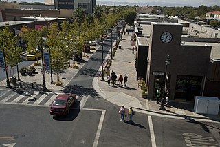
The redesign of Lancaster Boulevard helped transform downtown Lancaster into a thriving residential and commercial district through investments in new streetscape design, public facilities, affordable homes, and local businesses. Dubbed “The BLVD Transformation,” this comprehensive effort engaged residents and businesses to revitalize the formerly dilapidated downtown and make it a distinctive destination. Completed after just eight months of construction, The BLVD demonstrates how redesigning a corridor guided by a strategic vision can spark new life in a community. Photo courtesy of EPA. www.epa.gov/smartgrowth/awards/sg_awards_publication_2012... |
| Dät | |
| Fon | October 2012 - Overall Excellence in Smart Growth 2012: Lancaster, CA, The BLVD Transformation |
| Lautan | USEPA Environmental-Protection-Agency |
| Camera location | | View this and other nearby images on: OpenStreetMap |
|---|
.jpg¶ms=034.697907_N_-118.142037_E_globe:Earth_type:camera_source:Flickr_&language=vo)
Dälastad
This image (or other media) is a work of an Environmental Protection Agency employee, taken or made as part of that person's official duties. As works of the U.S. federal government, all EPA images are in the public domain.
|
||
| This image was originally posted to Flickr by usepagov at https://flickr.com/photos/24400159@N05/8634270433. It was reviewed on 1 tobul 2016 by FlickreviewR and was confirmed to be licensed under the terms of the United States Government Work. |
Jenotem ragiva
Välolös däti/timi ad logön ragivi soäsä äbinon ün tim at.
| Dät/Tim | Magodil | Mafots | Geban | Küpet | |
|---|---|---|---|---|---|
| anuik | 05:50, 2016 tobul 1id | | 5,616 × 3,744 (12.78 MB) | Vanished Account Byeznhpyxeuztibuo | Transferred from Flickr via Flickr2Commons |
Yüms
Pads sököl payümons ko pad at:
Ragivigeb Valöpik
The following other wikis use this file:
- Geb su ar.wikipedia.org
- Geb su arz.wikipedia.org
- Geb su azb.wikipedia.org
- Geb su be.wikipedia.org
- Geb su bg.wikipedia.org
- Geb su ca.wikipedia.org
- Geb su ce.wikipedia.org
- Geb su dag.wikipedia.org
- Geb su de.wikipedia.org
- Geb su en.wikipedia.org
- Geb su en.wikivoyage.org
- Geb su eo.wikipedia.org
- Geb su es.wikipedia.org
- Geb su eu.wikipedia.org
- Geb su fr.wikipedia.org
- Geb su ga.wikipedia.org
- Geb su he.wikivoyage.org
- Geb su ht.wikipedia.org
- Geb su hu.wikipedia.org
- Geb su it.wikipedia.org
- Geb su it.wikivoyage.org
- Geb su ko.wikipedia.org
- Geb su lld.wikipedia.org
- Geb su nl.wikipedia.org
- Geb su no.wikipedia.org
- Geb su pt.wikipedia.org
- Geb su ro.wikipedia.org
- Geb su ru.wikipedia.org
- Geb su sr.wikipedia.org
- Geb su sw.wikipedia.org
- Geb su szl.wikipedia.org
- Geb su tt.wikipedia.org
- Geb su uk.wikipedia.org
- Geb su uz.wikipedia.org
- Geb su www.wikidata.org
- Geb su zh.wikipedia.org
.jpg)