Ragiv:Mcchord-afb-20-06-02-01.jpg
Size of this preview: 317 × 599 pixels. Other resolutions: 127 × 240 pixels • 321 × 607 pixels.
Ragiv rigik (321 × 607 pixel, ragivagret: 98 KB, pated MIME: image/jpeg)
Plän brefik
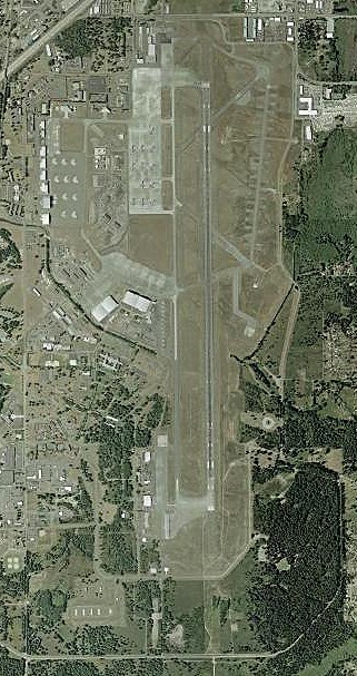
| Bepenam | USGS orthophoto of McChord Air Force Base (Washington State) |
| Dät | |
| Fon | USGS The National Map via MSR Maps (formerly TerraServer-USA) |
| Lautan | United States Geological Survey (USGS) |
| Däl (Reusing this file) |
Public domain |
Dälastad
This image is in the public domain in the United States because it only contains materials that originally came from the United States Geological Survey, an agency of the United States Department of the Interior. For more information, see the official USGS copyright policy.
|
Jenotem ragiva
Välolös däti/timi ad logön ragivi soäsä äbinon ün tim at.
| Dät/Tim | Magodil | Mafots | Geban | Küpet | |
|---|---|---|---|---|---|
| anuik | 03:21, 2007 yanul 5id | | 321 × 607 (98 KB) | Mike-tango | {{Information |Description=Satellite view from Mcchord Air Force Base (Washington state) |Source=http://terraserver-usa.com |Date=2002-06-02 |Author=Image courtesy of the USGS |Permission= |other_versions= }} Category:United States Air Force bases |
Yüms
Pads sököl payümons ko pad at:
Ragivigeb Valöpik
The following other wikis use this file:
- Geb su ar.wikipedia.org
- Geb su ceb.wikipedia.org
- Geb su de.wikipedia.org
- Geb su eo.wikipedia.org
- Geb su es.wikipedia.org
- Geb su fa.wikipedia.org
- Geb su fr.wikipedia.org
- Geb su nl.wikipedia.org
- Geb su no.wikipedia.org
- Geb su pl.wikipedia.org
- Geb su pt.wikipedia.org
- Geb su sr.wikipedia.org
- Geb su ur.wikipedia.org
- Geb su uz.wikipedia.org
- Geb su www.wikidata.org
- Geb su zh-min-nan.wikipedia.org