Ragiv:LocationTonga.png
Gretot gudikum no pagebidon.
LocationTonga.png (250 × 158 pixel, ragivagret: 6 KB, pated MIME: image/png)
Plän brefik
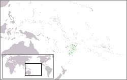
| Bepenam | Location map for Tonga | ||
| Dät | |||
| Fon | Vobot okik | ||
| Lautan | Created by: Vardion. Uploaded by: EugeneZelenko. | ||
| Däl (Reusing this file) |
|
Jenotem ragiva
Välolös däti/timi ad logön ragivi soäsä äbinon ün tim at.
| Dät/Tim | Magodil | Mafots | Geban | Küpet | |
|---|---|---|---|---|---|
| anuik | 15:15, 2004 dekul 21id | | 250 × 158 (6 KB) | EugeneZelenko | Location map for the Tonga.<br/>Originally created for English Wikipedia by Vardion.<br/>{{PD}}<br/>Category:Country locator maps |
Yüms
Pads sököl payümons ko pad at:
Ragivigeb Valöpik
The following other wikis use this file:
- Geb su af.wikipedia.org
- Geb su ar.wikipedia.org
- Geb su arz.wikipedia.org
- Geb su ban.wikipedia.org
- Geb su ba.wikipedia.org
- Geb su be-tarask.wikipedia.org
- Geb su be.wikipedia.org
- Geb su bg.wikipedia.org
- Geb su bn.wikipedia.org
- Geb su bo.wikipedia.org
- Geb su bpy.wikipedia.org
- Geb su bs.wikipedia.org
- Geb su ca.wikipedia.org
- Geb su ceb.wikipedia.org
- Geb su chr.wikipedia.org
- Geb su ckb.wikipedia.org
- Geb su cs.wikipedia.org
- Geb su cu.wikipedia.org
- Geb su de.wikinews.org
- Geb su de.wikivoyage.org
- Geb su de.wiktionary.org
- Geb su en.wikipedia.org
- Geb su en.wikivoyage.org
- Geb su eo.wikipedia.org
- Geb su eo.wiktionary.org
- Geb su es.wikipedia.org
- Geb su ext.wikipedia.org
- Geb su fa.wikipedia.org
- Geb su fiu-vro.wikipedia.org
- Geb su fo.wikipedia.org
- Geb su frp.wikipedia.org
View more global usage of this file.