Ragiv:Key Biscayne.jpg
Gretot gudikum no pagebidon.
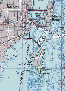
Key_Biscayne.jpg (264 × 365 pixel, ragivagret: 29 KB, pated MIME: image/jpeg)
Plän brefik
| Bepenam |
English: Key_Biscayne Map from http://chartmaker.ncd.noaa.gov/csdl/ctp/backg.htm |
| Fon | http://chartmaker.ncd.noaa.gov/csdl/ctp/backg.htm |
| Lautan | NOAA |
Dälastad
This image is in the public domain because it contains materials that originally came from the U.S. National Oceanic and Atmospheric Administration, taken or made as part of an employee's official duties.
|
Original upload log
The original description page was here. All following user names refer to en.wikipedia.
- 2003-08-07 20:37 Pascal 264×365× (29744 bytes) Key_Biscayne Map from http://chartmaker.ncd.noaa.gov/csdl/ctp/backg.htm
Jenotem ragiva
Välolös däti/timi ad logön ragivi soäsä äbinon ün tim at.
| Dät/Tim | Magodil | Mafots | Geban | Küpet | |
|---|---|---|---|---|---|
| anuik | 19:43, 2009 prilul 25id | | 264 × 365 (29 KB) | File Upload Bot (Magnus Manske) | {{BotMoveToCommons|en.wikipedia|year={{subst:CURRENTYEAR}}|month={{subst:CURRENTMONTHNAME}}|day={{subst:CURRENTDAY}}}} {{Information |Description={{en|Key_Biscayne Map from http://chartmaker.ncd.noaa.gov/csdl/ctp/backg.htm}} |Source=Transferred from [htt |
Yüms
Pads sököl payümons ko pad at:
Ragivigeb Valöpik
The following other wikis use this file:
- Geb su ar.wikipedia.org
- Geb su arz.wikipedia.org
- Geb su ca.wikipedia.org
- Geb su ceb.wikipedia.org
- Geb su cy.wikipedia.org
- Geb su de.wikipedia.org
- Geb su en.wikipedia.org
- Geb su es.wikipedia.org
- Geb su eu.wikipedia.org
- Geb su fr.wikipedia.org
- Geb su ht.wikipedia.org
- Geb su it.wikipedia.org
- Geb su ro.wikipedia.org
- Geb su www.wikidata.org
- Geb su zh-min-nan.wikipedia.org