Ragiv:Big Manila.jpg

Ragiv rigik (4,078 × 1,094 pixel, ragivagret: 1.1 MB, pated MIME: image/jpeg)

|
FOR CATEGORIES
Republic Act No. 8293 (the IP Code of the Philippines) as it stands today does not contain a freedom of panorama provision that permits free uses of images of copyrighted architectural or artistic works situated in public spaces. Please do not upload image files of such works here, unless their presence or inclusion in the image files is incidental. Architectural or artistic works that are now in public domain should be fine. FOR IMAGE FILES
Copyright warning: A subject in this image is protected by copyright. This image features a copyrighted architectural or artistic work (e.g. monument, sculpture, memorial, or mural), photographed from a public space in the Philippines. There are no freedom of panorama exceptions in the IP Code of the Philippines (R. A. No. 8293), which means that they cannot be photographed freely for anything other than personal purposes, reporting of current events, and educational/teaching purposes. More information: COM:CRT/Philippines#Freedom of panorama. If a copyrighted architectural or artistic work is contained in this image and it is a substantial reproduction, this photo cannot be licensed under a free license, and will be deleted. Framing this image to focus on the copyrighted work is also a copyright violation. Before reusing this content, ensure that you have the right to do so. You are solely responsible for ensuring that you do not infringe someone else's copyrights. See our general disclaimer for more information. |

Plän brefik
| Bepenam |
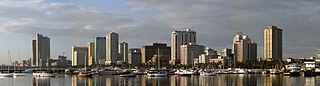
English: A panorama of the Manila skyline, taken from Harbour Square. |
| Dät | |
| Fon | Vobot okik |
| Lautan | Mike Gonzalez (TheCoffee) |
| Other versions |
Derivative works of this file: Manila banner.jpg File:Manila skyline 2007.jpg (original) |
| Camera location | | View this and other nearby images on: OpenStreetMap |
|---|
Dälastad
- Binol libik:
- to share – to copy, distribute and transmit the work
- to remix – to adapt the work
- Under the following conditions:
- attribution – You must give appropriate credit, provide a link to the license, and indicate if changes were made. You may do so in any reasonable manner, but not in any way that suggests the licensor endorses you or your use.
- share alike – If you remix, transform, or build upon the material, you must distribute your contributions under the same or compatible license as the original.

|
Däl pagevon ad kopiedön, seagivön e/u votükön dokümi at ma Dälazöt ad Dokümam Libik: GNU, Fomam: 1.2 u nulikum fa el Free Software Foundation (Stitod: Nünömaprograms libik); nen diläds nevotükovik, nen vödems tegapada balid, e leigo nen vödems tegapada lätik. Kopied dälazöta pekeninon in diläd: Dälazöt ad Dokümam Libik: GNU panemöl. |
Jenotem ragiva
Välolös däti/timi ad logön ragivi soäsä äbinon ün tim at.
| Dät/Tim | Magodil | Mafots | Geban | Küpet | |
|---|---|---|---|---|---|
| anuik | 08:59, 2020 mäzul 28id | 4,078 × 1,094 (1.1 MB) | Pandakekok9 | File:Manila skyline 2007.jpg cropped 22 % horizontally, 2 % vertically using CropTool with lossless mode. | |
| 20:53, 2007 yunul 16id | 2,040 × 560 (422 KB) | Dybdal~commonswiki | {{Information |Description=A panorama of the en:Manila skyline, taken from Harbour Square. Photo taken by Mike Gonzalez (en:User:TheCoffee) on April 5, 2007. Released under the GFDL. |Source=Originally from [http://en.wikipedia.org en.wikipedia |
Yüms
Pads sököl payümons ko pad at:
Ragivigeb Valöpik
The following other wikis use this file:
- Geb su ar.wikipedia.org
- Geb su arz.wikipedia.org
- Geb su ast.wikipedia.org
- Geb su az.wikipedia.org
- Geb su ba.wikipedia.org
- Geb su bcl.wikipedia.org
- Geb su be-tarask.wikipedia.org
- Geb su bn.wikipedia.org
- Geb su bn.wikivoyage.org
- Geb su ca.wikipedia.org
- Geb su cbk-zam.wikipedia.org
- Geb su ceb.wikipedia.org
- Geb su ce.wikipedia.org
- Geb su ckb.wikipedia.org
- Geb su crh.wikipedia.org
- Geb su cy.wikipedia.org
- Geb su da.wikipedia.org
- Geb su de.wikipedia.org
- Geb su de.wikivoyage.org
- Geb su diq.wikipedia.org
- Geb su el.wikipedia.org
- Geb su en.wikipedia.org
- Geb su en.wikivoyage.org
- Geb su eu.wikipedia.org
- Geb su fiu-vro.wikipedia.org
- Geb su fi.wikipedia.org
- Geb su fr.wikivoyage.org
- Geb su ga.wikipedia.org
- Geb su gd.wikipedia.org
- Geb su gl.wikipedia.org
- Geb su gn.wikipedia.org
- Geb su ha.wikipedia.org
- Geb su he.wikipedia.org
- Geb su he.wikivoyage.org
- Geb su ht.wikipedia.org
- Geb su hu.wikipedia.org
View more global usage of this file.